District 1 Information
| School Board District 1 - Kalifornsky | ||
|---|---|---|
 Sammy Crawford | ||
| Term Expires: | ||
| Previously Elected: | ||
| District Location: | See description below | |
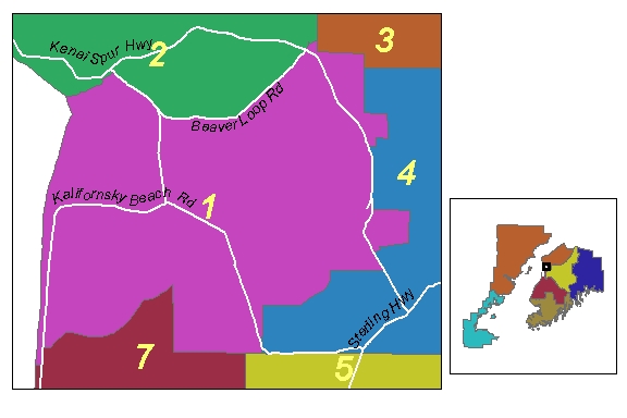
Kenai Peninsula Borough Code 22.30.010
Commencing at the section corner common to Sections 33, 34, T5N, R11W;
Thence north to the intersection of said section line and the centerline of Unocal Airport Road;Thence southwesterly along Unocal Airport Road to the intersection with centerline of Kalifornsky Beach Road;Thence south along the centerline of Kalifornsky Beach Road to the intersection of the north 1/16 line of Section 1, T4N, R12W;Thence west to the mean high water line of Cook Inlet;Thence northerly along the mean high water line to the intersection of the section line common to Sections 7, 8, T5N, R11W;Thence north to the intersection of the right bank of the Kenai River also being the mean high water line of the Kenai River;Thence northeasterly along the mean high water line of the Kenai River to the intersection of the thread of Ryan's Creek;Thence northerly along the thread of Ryan's Creek to the intersection of centerline of Frontage Road;Thence northeasterly along the centerline of Frontage Road to the intersection of the centerline of Bridge Access Road;Thence southerly along centerline of Bridge Access Road to intersection of the centerline of Beaver Loop Road;Thence easterly along the centerline of Beaver Loop Road to the intersection of the Kenai Spur Highway and Shotgun Drive;Thence north along the centerline of Shotgun Drive to the intersection of range line common to T6N, R11W AND T6N, R10W;Thence south along the range line to the south 1/16 corner of Section 31, T6N, R10W;Thence east along the south 1/16 line to the intersection of Sections 31, 32, T6N, R10W;Thence south along the section line to the section corner common to Sections 5, 6, 7, 8, T5N, R10W;Thence east to the 1/4 corner common to Sections 5, 8, T5N, R10W;Thence south to the center 1/4 corner of Section 8, T5N, R10W;Thence west to the center west 1/16 of Section 8, T5N, R10W;Thence south to the southwest 1/16 corner of Section 8, T5N, R10W;Thence west to the centerline of the Kenai Spur Highway;Thence southerly along centerline of the Kenai Spur Highway to the centerline of the intersection of Sport Lake Road;Thence east along Sport Lake Road to the centerline of Moser Road also being a section line common to Sections 20, 21, T5N, R10W;Thence south to the intersection of the centerline of the Alaska Natural Gas Pipeline right-of-way;Thence westerly along the pipeline centerline right-of-way to the centerline of Delta Avenue;Thence westerly along the centerline of Delta Avenue to the centerline of Gibson Blvd;Thence south along centerline of Gibson Blvd to the centerline of Kilowatt Avenue;Thence westerly along the centerline of Kilowatt Avenue to the centerline of the Kenai Spur Highway;Thence southerly along the centerline of the Kenai Spur Highway to the north 1/16 line of Section 29, T5N, R10W;Thence west along the north 1/16 line to the intersection of the thread of the Kenai River;Thence southwesterly along the thread of the Kenai River to the section line common to Sections 25, 36, T5N, R11W;Thence west along said section line to section corner common to Sections 25, 26, 35, 36, T5N, R11W;Thence south to the section corner common to Sections 35, 36, T5N, R11W and the township line common to T4N & T5N;Thence west along said township line to the point of beginning, and all being within the Seward Meridian, Alaska.